
National
Met. Dept.: Remain Ready for Severe Weather
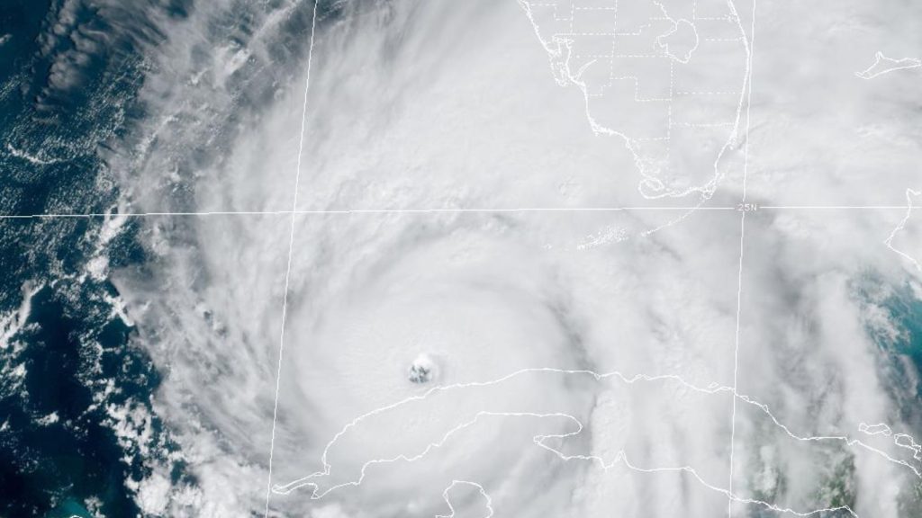
NASSAU, BAHAMAS – Rain from hurricane Ian is expected to affect the northwest islands of The Bahamas through Friday, according to the latest severe weather statement, issued by the Department of Meteorology.
NASSAU, BAHAMAS – Rain from hurricane Ian is expected to affect the northwest islands of The Bahamas through Friday, according to the latest severe weather statement, issued by the Department of Meteorology.
At 11am, hurricane Ian was located 305 miles south southwest of Sarasota Florida, or about 325 miles southwest of Alice Town Bimini, 365 miles southwest of Red Bays Andros, 380 miles southwest of West End, 390 miles southwest of Freeport Grand Bahama, 465 miles southwest of Marsh Harbour and about 420 miles southwest of New Providence. Ian is moving on a northerly track with a forward speed of 10 miles per hour, maximum sustain winds are 115 miles per hour.
“Due to its large expanse and the fact that the islands are located on the strongest side of the storm, rainbands from Hurricane Ian will continue to bring heavy rains, severe thunderstorms with dangerous lightning, gusty winds and possible tornadic activity to the Northwest Bahamas, in particular the islands of Bimini, Grand Bahama, Abaco, the Berry Islands and Andros,” the statement says.
Total rainfall amounts of 4 to 6 inches, are expected with isolated amounts of up to 8 inches through Friday.
Severe localized flooding is possible in “low-lying, and flood prone areas”.
Residents should look out for minor coastal flooding along the east and south coasts during the high tide cycle. Residents are advised to exercise extreme caution while moving about today and the remainder of the week.
Wind gusts up to tropical storm force can be expected on islands in the extreme northwest Bahamas (Bimini, Grand Bahama, the Berry Islands and Abaco their surrounding waters and Cays), where winds are forecast to reach near gale force (28 to 33 knots).
Mariners and boaters in these area, are to remain in port and beachgoers are advised to refrain from entering the waters.
“The public is reminded that storms DO NOT move in a straight line, they tend to wobble. Therefore, a state of readiness should be maintained in the event the Ian tracks farther east.”
Severe Thunderstorm Warnings will be issued, when required, throughout the day and into Friday. Residents are advised to pay close attention to all warnings/statements issued by The Bahamas Department of Meteorology (BDM).


Bahamas Dept. Of Immigration Marches Into the History Books

Families Mourn Four Teens Killed in Shirley Street Crash

Long Island MP Rebuked After “Beseeching” House Speaker

DEPP Director: Development Must Not Come At Environment’s Expense

Lifelong Lessons for Templeton Laws of Life Awardees

GB Chamber Hosts a Seminar for Disaster Preparedness and Business Continuity

Three Teens Facing Charges Over Alleged Gang Rape Of 15-Year-Old Girl
Man Gets 12-Years In Jail For Sex With 12-Year-Old Girl

4th Direct Cash Relief Since 2021 Targets 13,000 TCI Citizens

Ukraine Unleashes One of Its Heaviest Drone Bombardments of Russia

Four Teenage Girls Dies In Fatal Car Crash

Updating the Law Governing Private Security
Bahamas Dept. Of Immigration Marches Into the History Books
Families Mourn Four Teens Killed in Shirley Street Crash
Long Island MP Rebuked After “Beseeching” House Speaker
DEPP Director: Development Must Not Come At Environment’s Expense
Lifelong Lessons for Templeton Laws of Life Awardees
GB Chamber Hosts a Seminar for Disaster Preparedness and Business Continuity

-
 Court3 days ago
Three Teens Facing Charges Over Alleged Gang Rape Of 15-Year-Old Girl
-
Court3 days ago
Man Gets 12-Years In Jail For Sex With 12-Year-Old Girl
-
 Regional3 days ago
4th Direct Cash Relief Since 2021 Targets 13,000 TCI Citizens
-
 International3 days ago
Ukraine Unleashes One of Its Heaviest Drone Bombardments of Russia
-
 National23 hours ago
Four Teenage Girls Dies In Fatal Car Crash
-
 National23 hours ago
Updating the Law Governing Private Security
-

 National2 days ago
The U.S. Embassy in The Bahamas Kicks Off Independence Celebrations
-

 Education2 days ago
GB’s Beta Camp Makes Learning Feel Less Like School, More Like An Adventure